“Oh misty eye of the mountain below…”
The lyrics from Ed Sheeran’s “I See Fire” raised the hairs on our arms as we drove across England toward Wales and Snowdonia National Park. Yes, The Hobbit films were shot in New Zealand but the landscapes in this part of the world are similar enough that the Welsh valleys could quite easily have doubled for parts of Middle Earth.
We had decided to climb Snowdon in July 2017 and as always in the UK, hoped the weather would permit us to do so. We’d planned an extra day in the event we had to scrap an ascent due to bad weather. As we arrived at our campsite just outside the tiny village of Rhyd Ddu hopes were somewhat lacking as the rain lashed down with such force the windscreen wipers could barely keep up.
Previously we’d had to double back for a half hour to grab petrol and supplies from Tesco supermarket. We’d made the mistake of thinking the petrol stations closer to Snowdonia National park had updated to the twenty first century and had prices to match. No luck. After a frustrating ten minutes trying to get enough signal for Google maps to work we made the round trip and now, with a bag full of supplies and a full tank of petrol we crossed in to the parklands.
Wow! The views immediately opened up revealing rolling hills, forests, and more importantly, mountains. The traditional stone walls on either side of the road guided us through villages, fields with livestock, and bridges over bubbling streams. Already the excitement for adventure had stirred.
We arrived at the camp grounds run by the Cwellyn Arms pub during a downpour. Braving the rain to open the gate and let the car through we drove around the site and looked for a suitable spot to pitch the tent. Not too close to the nearby river or lake as we knew better than to tempt hungry midges that usually buzz around them.
After a few minutes of optimistically waiting for the rain to subside, we realised that a backtrack to the pub was necessary in order to sign in and collect firewood. The Cwellyn Arms is one of those places that evokes a certain feeling in mountainous regions. The warm atmosphere, the smell of a log fire, and the buzz of patrons talking about their hikes or cycling routes.
After checking in and grabbing a bag of firewood and kindling we drove back to the campsite. Still raining but we had to pitch a tent before darkness fell. It had been a long drive across country and pitching an awkwardly designed tent in the cold and wet may not have been the most auspicious start to our time in Wales!
We had decided to eat dinner at the pub that evening. The weather had prevented us from cooking outside and it seemed right to check out the local fare anyway. The meal itself was delicious and satisfied a hunger however tiredness had set in and due to our relatively early start the next morning we called it a night and retired to the tent. After a stint watching downloaded Netflix content on our tablet sleep came easy.
The next morning we rose early and drove a bit further up the road to a Hostel where we purchased an OS map of Snowdon (didn’t really need it as the routes are well signposted and worn but it’s best to be careful on a mountain) and after finding parking opposite the pub we walked across a train track to the start of the Rhyd Ddu Path route. Start time around 9:40am.
The weather had completely flipped and the sun shone above as we strolled along the first, flat section towards the main ascent. Around ten minutes later we reached the first dramatic rock formation and started the climb.

Around 10mins in. Photo taken by Steve Collier. Copyright, 2017.
The going was good as we climbed. We followed the path and made it to a stream running down the mountain. To get up, we needed to scramble up the stream for a bit. This is where the climb became steeper. As with all long walks, conversation turns to focus as you put one foot in front of the other, your limbs working in perfect unison to balance, climb, and haul yourself up near vertical boulder sections. All other thoughts clear from your head. It’s almost meditation and amongst the remote landscape, the silence is enjoyable. Occasionally we’d overtake someone or vice versa. Holding back or powering ahead for a short while meant we weren’t walking next to other people that often. The Rhyd Ddu track is a lot quieter too although after doing research prior to the hike the views seem more enjoyable if a little more challenging.

Around halfway. Photo by Nicola Attridge. Copyright, 2017.
At around halfway at the crest of Llechog with a jaw dropping crescent valley spread out before us we decided to sit down and have a short break. The scale of the vista in front of us was difficult to give a sense of scale with a camera. Only the distant ant-like figures of walkers following the ridge line further ahead gave the scene perspective.
We’d packed dates, cashews, almonds, bananas, cereal bars, and a few other snacks. A full picnic is not what you want with the rest of the climb to go. By the way, on a long hike, scrap the water bottles and grab a Platypus pack. We’ve used them for years (Steve’s had one since the early 2000’s!) and they’re excellent. You can see the drinking tube on Steve’s left shoulder in the above picture. This connects to a tough, rollable, plastic pouch in the backpack holding the water. To drink you bite down on the valve and suck the water through. This one holds three litres of water and you can buy it here if you like. The great thing about them is as you drink, the pouch shrinks therefore easing your shoulders and giving you more space in your bag unlike a solid bottle. Highly recommended.

Can you spot the hikers on the ridge line on the top right on the picture?! Photo by Nicola Attridge. Copyright, 2017.
After the break we rejoined the route and got the legs moving again. This part of the hike is where the path became narrower, following the ridge along Bwlch Main. This part of the walk was spectacular although somewhat hair raising if you have an issue with heights. Or rather, falls! A steep drop to the left and loose rock on the right means you need to be extra careful here, especially in adverse weather conditions. This part opens up a bit and the other side of the ridge opens up on the right as you enter a section of tall, craggy formations (of which we neglected to take pictures!) which you’ll need to pick your way through. You’re now at the height at which birds of prey circle below you, using the thermals to elevate with minimal effort. This was easily the most spectacular section of the climb and felt like you’re in a fantasy world where a giant might well challenge you to a duel at any moment. In fact there are many legends associated with this mountain and it’s not hard to conjure images of mystical being emerging from the mists swirling around the monolithic terrain.
In fact this is the point at which the weather started to turn. Clouds rolled in, causing the way forward to be hidden from view only to reappear and then return back in to the ether once more. The temperature had dropped and the layers previously packed away were unfurled and slipped on. Nearly there.
The final hurdle was a straight walk to the top. The sound of crowds drifted down to us on the rising wind and somehow the tiredness decided to hit home. Reaching the station at the top was an incredible feeling, It always is to climb something or reach a goal like that. The atmosphere at the top was one of elation and excitement. Climbers milled around clutching hot drinks and snacks purchased from the heaving cafe inside the main building. Those that reached the summit by train enjoyed the view but sheepishly walked among the weather beaten hikers.
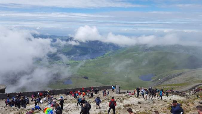
A view from the top as the weather rolls in. Photo by Nicola Attridge. Copyright, 2017.
The queue to touch the summit waypoint took a while to move due to the sheer amount of pictures being taken. Understandable and not annoying. We’d be doing exactly the same. Groups climbing for charity, kids, elders, disabled people, racers, and dogs all connected by this shared experience of conquering this mountain. Admittedly this is by no means a huge climb but it’s the feeling of adventure, the release of endorphins, the sense of accomplishment, and the shared experience which causes elation. After all the weather could have caused us to cancel the climb at all and people have actually dies while climbing Snowdon.
We touched the plaque on top, took pictures and made our way to the summit station for sustenance, a toilet, and a sit down!

The plaque at the very top. Got to touch it! Photo by Nicola Attridge. Copyright, 2017.
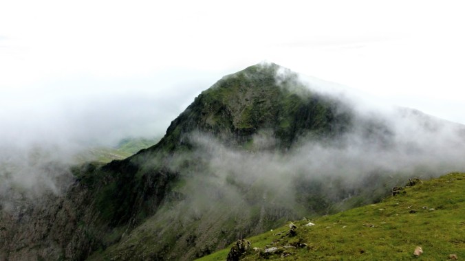
For our route down we chose the Ranger track as it took us down towards the hostel and then it was a short walk back around the lake to the campsite. Of course, although this route was easy, the descent is harder when your legs are dealing with exhaustion and the rain starts to pour. The temperature dropped majorly as soon as we left the summit station and the wind became intense and icy. We both had some handy neck scarves which could be double up as balaclavas or headbands and these came in really useful here. The first, relatively flat section of the Ranger track on the way down went along an exposed ridge line that offered zero shelter from the weather. Regardless, Steve decided to quickly dash up another peak, Garnedd Ugain which upon writing this article we have found to be the second highest peak in Wales at 1065m/3494ft. The view from this peak can be seen in the photo at the top of the article. The clouds did part for one photo but the mists look a bit more cinematic!
We made our way down, mostly either following or walking ahead of an organised group. We were quite glad of the company as it made the descent slightly less dismal. There were some fairly high steps to negotiate as well as the usual scrambles and streams which in the rain and with slightly wobbly legs, made the experience pretty tiring. Somehow we managed to miss a turning that would have acted as a shortcut and a direct route back to Rhyd Ddu even though the map clearly showed it should have been visible. No idea where the track was. Perhaps it cut through farmland but either way we took the Ranger track to the end and walked back to the campsite via the narrow, country road with the lake on our right.
Just in time for another solid downpour, Steve walked a bit further, back to the car in the village, returning to the campsite completely soaked even though he’d managed to stay relatively dry the whole day! Showers, and sleep followed. No energy to cook dinner. The warm blankets and soft pillows invited us to let go of the aches and groans. We’d done it.
The next morning and the sun was out again. We had a lot of food left from the last couple of days and it needed using so we decided to cook breakfast over the fire and relax as the checkout time was generous. We’d bought some marshmallows (and vegetarian versions) to make smores- something we’d planned to do the night before. We cut some thin sticks from the trees by the river, stripped the bark away to expose the less flammable green fibres and sharpened the ends to spear the marshmallows. Cheat tip- grab chocolate oaties or chocolate hob nobs and sandwich the melted marshmallows between them so the chocolate melts for a quicker and perhaps more enjoyable version. Heaven! A perfect end to our time here.

Cheat smores. No messing around! Photo taken by Nicola Attridge. Copyright, 2017.
We drove out to Caernarfon and explore Wales a little more after Snowdon but that’s another story.
To finish we thought it might be useful to link to some kit we took that we found useful. It’s important to be prepared on hikes and the danger of even smaller mountains should not be underestimated. Check these bits out and let us know if you’ve been or are planning to climb Snowdon via our Facebook page or in the comments below. We’d love to hear from you.
Kit suggestions:
Karrimor Hot Rock Shorts – Steve wore these. Super comfortable, stretchy, well fitted, robust material and waterproof with a zip pocket. Love them.
Lifeventure packable 18L daysack – We’ve both had these since 2014 and have taken them around the world, through jungles, beaches, hikes, and everyday use around town. Lifeventure make great stuff. These bags pack in to the themselves, are incredibly lightweight and strong. They’re only starting to wear after 4 years of near everyday use.
Ruffneck multifunctional neck scarf – An essential on this hike. Easy to wear, use and a variety of functions. Warm, stretchy and soft. Had them for years. They go on every trip. UK made and some great designs! Love the shark one.
Platypus 3L hydration pack – Said it before but they’re brilliant. You can keep you hands free with the clip on hose/straw which is essential while climbing.
Leatherman Wingman multitool – This is the basic version from the original and best Portland based company. Every foldaway tool you could need while camping and hiking. Always carry one just in case. 25 year guarantee too.
These guys have a great, pictorial guide complete with OS map of the Rhydd Ddu route and every other route up Snowdon.
Until next time, happy travels!
*This post does contain some affiliate links which simply means links to stuff we genuinely like and own/use. You don’t pay any more but if you use the links above it helps us with a tiny % kickback for the recommendation. We have not received any money to recommend anything on this post.
